The lease map in Mahoning County, Ohio, shows that the contiguous acreage required for drilling is taking shape. Leases recorded with the Mahoning County recorder in 2026, through Oct. 28, cover about 18,000 acres on more than 1,400 parcels. Contiguous acreage is what lets an operator form a drilling unit. Those acres come from 835 leases recorded this year, compared with 82 in all of 2025 and a single lease in 2024. Because leases typically take about 30 days to reach the recorder’s online index, the true totals as of this writing are likely higher.
Distinct clusters are emerging. In these areas, first movers may already hold, or soon will hold, enough contiguous acreage to form units, file permits, and drill the next modern Utica/Point Pleasant well in the county. Two maps help tell the story.
Topic section guide for this article
- Leased parcel map shows distinct areas of focus
- Map: Mahoning County leased parcels by lessee and the areas to watch for activity
- Wehr Spring Valley well anchors the leased corridor
- Who holds the acreage? Who could move first?
- Table: 2026 Mahoning County leases and acreage by lessee
- Why leasing thins toward the Columbiana County line
- Legacy wells and clouded titles help explain the gaps
- Map: Producing wells versus leased acreage
- Clearing title takes time: old leases, dormant minerals and delayed bonuses
- What landowners might expect
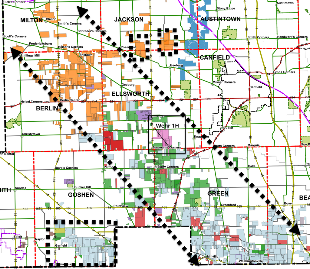
Leased parcel map shows distinct areas of focus: one main trend and a few areas set apart
The leased parcels plotted on the map fall into distinct groups. Each color is a different lessee, and the parcels show distinct clustering. The densest leasing sits in a corridor running northwest to southeast across Berlin, Ellsworth, Goshen and Green townships. Detached pockets also appear in Jackson Township and along the southern county line near Damascus, Millville and Washingtonville with these clusters likely extending into Columbiana County to a degree.
Wehr Spring Valley well anchors the leased corridor
In the middle of the northwest-to-southeast corridor sits the Wehr Spring Valley Farm 1H in Ellsworth Township, at State Route 45 and Leffingwell Road. Encino drilled it in spring 2025. ODNR issued the permit May 1, the well was fracked in mid-June, and EOG Resources now owns it. Its first quarter on production was Q3 2025, at about 40,489 barrels of oil and 203,299 Mcf of gas. No other horizontal well in the county topped 339 barrels of oil that quarter. Over its first four quarters, Q3 2025 through Q2 2026, it produced about 97,100 barrels of oil and 615,300 Mcf of gas. For a county long written off after disappointing early Utica results, one well changed the conversation.
The Wehr lateral runs about 7,700 feet from northwest to southeast. That orientation isn’t random. Across the Appalachian Basin, the maximum horizontal stress runs roughly east-northeast. Operators drill laterals across it so hydraulic fractures open crosswise to the wellbore, and most Ohio Utica wells run NNW–SSE to NW–SE. Units are drawn as long rectangles matching that azimuth. So operators building units off the Wehr template are leasing in elongated NW–SE blocks, and the corridor on the map supports that. At about 7,700 feet, Wehr is short by today’s standards. Apart from exploratory wells like it, new Utica wells are increasingly drilled with laterals of about 3 miles, roughly 15,800 feet or about twice Wehr’s length. A single 3-mile well would need about 300 to 370 contiguous acres, depending on well spacing, compared with Wehr’s 150.6-acre unit.
Results like Wehr’s also reduce risk for the acreage around it. Proving the Point Pleasant can deliver oil at commercial rates here makes the neighboring tracts the lowest-risk next step.
Who holds the acreage? Who could move first?
Two lessees dominate the 2026 recordings. The Del Rio III entities and Frio Resources II together hold nearly 13,000 of the roughly 18,000 acres recorded this year. Several lessees on the list are land-service companies or investment vehicles, so the operator behind the acreage may not be public yet.
| Lessee | Leases | Leased acres | Main townships |
|---|---|---|---|
| Del Rio III (SPV entities) | 239 | 7,147 | Green, Beaver, Goshen |
| Frio Resources II LLC | 279 | 5,825 | Berlin, Ellsworth, Milton, Jackson |
| OGM Partners LLC | 179 | 2,317 | Green, Ellsworth, Goshen |
| Logana Exploration LLC | 68 | 1,826 | Green, Ellsworth, Goshen, Beaver |
| DPS Land Services LLC | 47 | 408 | Goshen, Green, Ellsworth |
| Morning Gun Energy LLC | 6 | 240 | Coitsville |
| Bright Rock Energy LLC | 12 | 115 | Smith, Goshen |
| Others (3 lessees) | 5 | 112 | Berlin, Ellsworth, Green |
| Total | 835 | 17,990 |
Lease totals alone don’t make a first mover. An operator needs contiguous acreage: enough adjoining tracts, laid out in the long NW–SE rectangles that Utica laterals require, to form a unit and file for a permit. Scattered parcels, however many, can’t be drilled until the gaps are filled, either by more leasing or through ODNR unitization, which requires the operator to control at least 65% of the proposed unit. That makes the solid blocks on the map the places to watch. Frio’s acreage is concentrated in Berlin and Ellsworth townships at the northwest end of the corridor, while Del Rio’s is weighted toward Green, Beaver and Goshen to the southeast. Whichever lessee first assembles a contiguous block of unit size, and is convinced the economics work, is the likeliest to file the next permit. At $4,000 an acre, a single 3-mile unit of 300 to 370 acres represents $1.2 million to $1.5 million in signing bonuses alone. Across the roughly 18,000 acres leased this year, operators and their backers have committed tens of millions of dollars, a positive sign for landowners hoping for future royalties.
Why leasing thins toward the Columbiana County line
If the Wehr well proved up the corridor, the next question is why operators haven’t pushed harder to the southwest, toward the Columbiana County line and wells like EOG’s Kitzmiller CL KNX 10H in Knox Township, which produced about 354,000 barrels of oil in its first year. On paper, the case there is stronger. The Point Pleasant is deeper and higher pressure, and it lies closer to western Columbiana County, where EOG’s wells have performed well. Leasing is happening there, and at a premium. Green and Goshen townships, which border Columbiana County, account for nearly 7,000 of the acres leased this year, and bonuses there were running around $5,000 per acre with 20% royalties as of early August, according to attorney Alan Wenger, against $2,500 to $3,500 per acre and 18% royalties elsewhere in the county (Business Journal Daily, Aug. 4, 2026). The same report described the Green Township leasing as somewhat speculative, since few productive wells there show what the rock can do. But on the map, that acreage is split. Some sits inside the main corridor and some in detached pockets along the county line, with a wide unleased gap between them across southern Goshen and Green. The reason, I believe, is what lies beneath the surface from earlier drilling.
Legacy wells and clouded titles help explain the gaps
The second map, showing producing wells, points to why the area southwest of the Wehr Spring Valley Farm 1H, toward the western Columbiana wells, may not be seeing the leasing activity shown on the lease map above. Producing oil and gas wells are noticeably fewer in the areas being leased most heavily. ODNR lists 355 producing wells in Smith Township and 319 in Goshen, the most of any townships in the county, yet those two townships account for only about 1,900 of this year’s leased acres. Green, Berlin and Beaver, by contrast, have between 120 and 181 producing wells each and about 11,000 leased acres combined (ODNR Ohio Oil & Gas Wells map).
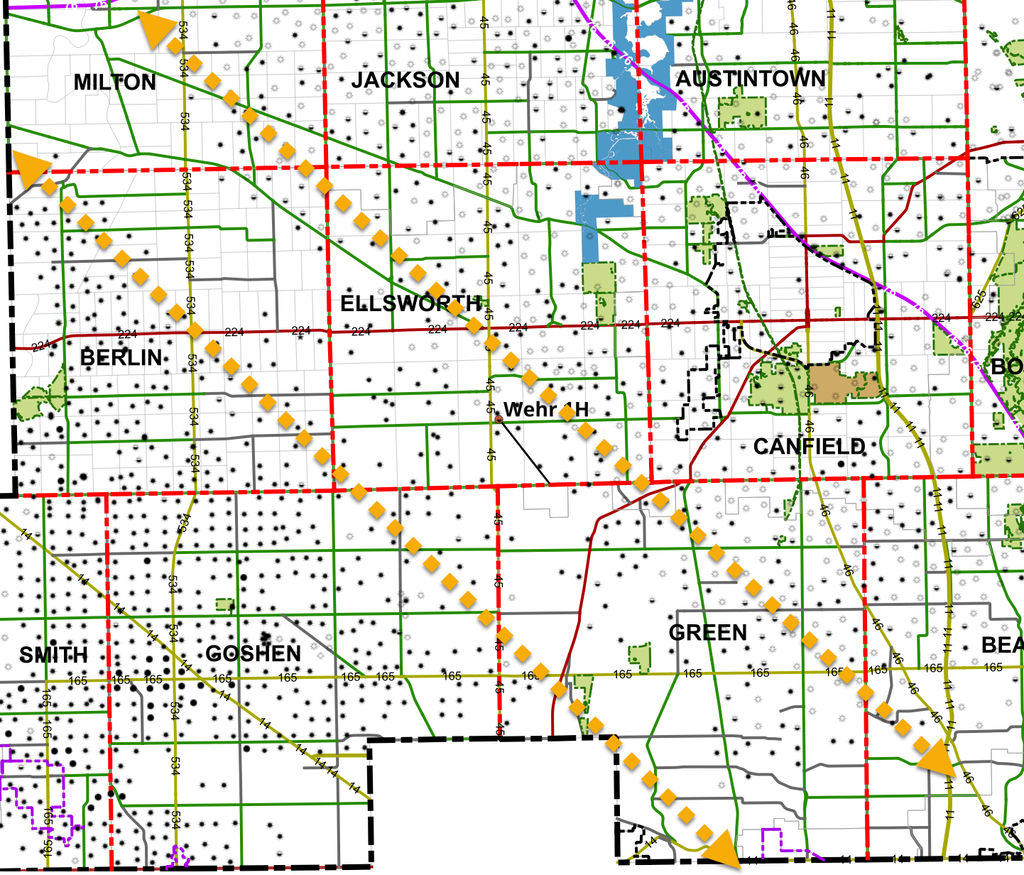
That pattern reflects the county’s past. Mahoning County has been drilled for more than a century. Most of those wells are shallow vertical wells into the Clinton sandstone, and each one came with a lease. Many of those leases were never formally released. Some are still held in force by wells that produce modest volumes today.
That history matters because an old lease usually covers all depths, not just the Clinton. Until it is released or otherwise cleared, it can cloud title to the Utica/Point Pleasant rights beneath the same tract. A landman can’t close a new lease, and an operator won’t pay a signing bonus, until the title examiner signs off. The issue is more about the time needed to create a clean lease. Those acquiring leases acted on the easier acreage first likely because it was simpler, not necessarily because it is the best acreage.
Clearing title takes time: old leases, dormant minerals and delayed bonuses
Where a lease has expired under its own terms, typically because production stopped, Ohio law gives landowners a way out. Under Ohio Revised Code 5301.332, a landowner sends the lessee a notice of forfeiture. After 30 to 60 days, the landowner records an affidavit of forfeiture. If the lessee doesn’t respond within 60 days, the recorder can mark the lease cancelled. But if the lessee files a counter-affidavit saying the lease is still valid, the matter goes to court. The forfeiture route works only where the lease has actually ended by its terms, which in practice means no producing well is holding it. Where a shallow well is still producing, the landowner’s only options are a negotiated release, a release of the deep rights, or litigation over whether the well still produces in “paying quantities.” Any of these can take months or years.
Severed mineral interests add another layer. In Corban v. Chesapeake Exploration (2016), the Ohio Supreme Court held that the 1989 version of Ohio’s Dormant Mineral Act was not self-executing; severed minerals did not pass to surface owners automatically. Surface owners must instead follow the notice-and-abandonment procedure in the 2006 amended act before they can claim abandoned minerals. That leaves more title work to finish before a lease is clean.
Even after signing, payment isn’t immediate. Bonuses are commonly paid by draft after a title review period. In Jefferson County, more than 50 landowners sued in 2015 after bonuses due within 120 days of signing went unpaid. Some said title defects were raised only after that deadline had passed.
Fragmented ownership compounds all of this. The 150-acre Wehr unit itself lists about 20 royalty owners, one of them holding just 0.058 acre. Multiply that by a legacy lease and an old wellbore on every few tracts, and it’s clear why landmen go after the cleaner acreage first. In much of the county, that cleaner acreage sits close to the Wehr well.
Operators also have to locate and evaluate old wellbores near planned laterals. An unplugged or poorly plugged well can take on fluid during a frac. That adds engineering review, and sometimes plugging work, before a unit is final.
What landowners might expect
Many factors shape the path from lease signings to permits to wells drilled. What is clear is that potential drilling units in Mahoning County are taking shape, and permits are likely to follow. Operators are weighing everything from their backlog of permitted but undrilled wells to oil and natural gas prices and the cost of getting production to market. Based on recent results from nearby modern wells, operators are betting that new wells will be drilled in Mahoning County. For landowners in areas not yet leased, especially where old producing wells complicate clearing title, it is likely just a matter of time before the legal work is done, the land is leased, and the rights to drill are secured.
Sources:
- Ohio Revised Code 5301.332
- KWGD: Removing Expired Oil & Gas Leases from Your Chain of Title
- Ohio Farm Bureau: Oil and Gas Leasing in Ohio guide
- Corban v. Chesapeake Exploration (2016), Justia
- Farm and Dairy: Jefferson County lawsuit seeks $9.2M in lease bonuses
- Vindicator: Industry interested in horizontal well results
- Salem News: Ellsworth well increases interest in Mahoning County
- Business Journal Daily: Oil, Gas Leases Skyrocket
- NGI: Titles, Spacing, Pooling Are All Potential Issues in Ohio
- Mahoning County Recorder: recorded oil and gas lease records
- Ohio Department of Natural Resources, Division of Oil and Gas Resources Management: well permits and quarterly horizontal well production data