
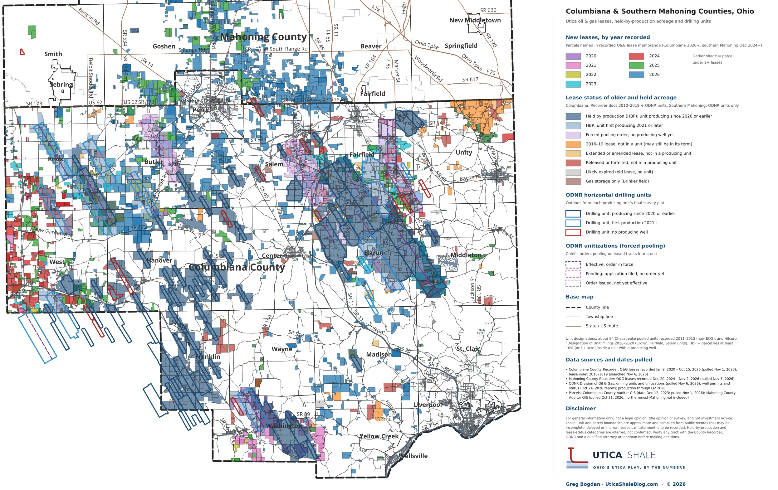
Oil and gas leases, held-by-production acreage and horizontal drilling units in Columbiana County and southern Mahoning County, Ohio.
Data current through October 15, 2026 (Columbiana leases), November 2, 2026 (Mahoning leases) and November 6, 2026 (ODNR drilling units). Maps are updated as new leases are recorded and new units are filed.
Leases, Held Acreage and Drilling Units
(2020 – October 2026)
The Columbiana County Utica/Point Pleasant play has two chapters. The first chapter was written when Chesapeake pooled about 84 horizontal units here between 2011 and 2015, most now operated by EOG, and Hilcorp followed with units around Elkrun, Fairfield and Salem from 2016 to 2020. Those dark blue units in Franklin, Hanover, Center, Fairfield, Elkrun and Washington townships hold much of the county’s older lease acreage by production today.
The next chapter is the leasing on top of it. Leases recorded since 2020 are colored by year. The 2024 and 2025 activity concentrates along the western edge in West and Knox townships, while the 2026 leasing fills northern Columbiana around Perry, Butler and Salem and carries straight across the county line into Goshen, Green and Beaver townships in southern Mahoning, mostly beyond the existing drilling units. That is the leasing front moving north into the Northern Tier.
Older acreage is shaded by its likely status: held by production inside a producing unit, under an ODNR forced-pooling order, a 2016–2019 lease that may still be in its term, extended or amended, or released, forfeited or likely expired. Darker shading marks parcels under two or more leases, common where joint owners each sign. Dates are “Recorded” dates vs. lease signed dates.
Source and Disclaimer
Source: Memoranda of oil and gas leases recorded with the Columbiana County Recorder (2010 through October 15, 2026) and the Mahoning County Recorder (December 2024 through November 2, 2026); horizontal drilling units, unitization orders, well permits and production from the ODNR Division of Oil and Gas Resources; parcel boundaries from the Columbiana and Mahoning County Auditor GIS. Compiled and mapped by Greg Bogdan, UticaShaleBlog.com.
Disclaimer: These maps are for general information only. Lease, unit and parcel boundaries are approximate and compiled from public records that may be incomplete, delayed or in error. Held-by-production and lease-status categories are inferred, not confirmed. Unrecorded leases and later assignments, releases or expirations may not be shown. Nothing here is a title opinion or legal, investment or land advice. Verify any tract with the County Recorder, ODNR and qualified professionals before making decisions.